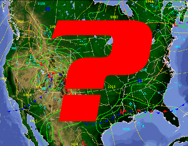
What kind of winter can YOU expect?
Once again, it’s that time of year when all of us skiers are wondering what the 2009-2010 winter has in store for us. Will it bring big snow storms with lots of power skiing and technical ski lines filling in for sickbird descents, or clear and dry weather with lots of blue skies allowing for long tours and overnight trips into the mountains? As usual, the predictions from the experts are somewhat varied and here’s what I’ve found.
Inter-Mountain– Winter temperatures will be above normal, with the coldest periods in early to mid-December and early February. Precipitation will be above normal, with below-normal snowfall from Reno to Salt Lake City and above-normal snowfall in most other areas. The snowiest periods will occur in early and mid-November, mid- and late December, and mid- and late January. April and May will be slightly warmer and wetter than normal.
Pacific Northwest-Winter temperatures and precipitation will be near normal, on average, with above-normal snowfall. The coldest periods will occur in early to mid- and late December, mid-January, and early to mid-February, with the snowiest periods in mid-December, early January, and mid-February. April and May will be warmer than normal, with near-normal rainfall in Washington and drier-than-normal conditions elsewhere.
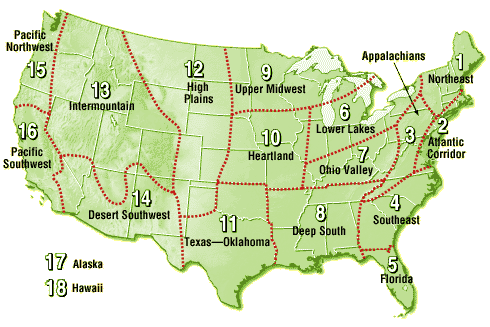
Pacific Southwest-Winter temperatures will be near normal in the north, on average, with above-normal rainfall. In the south, temperatures and rainfall will be below average. The stormiest periods will occur in early November, mid- and late December, and late January. Expect the coldest periods to occur in early and late December, early January, and early February. April and May will be cooler and rainier than normal.
Northeast-Winter will be colder than normal, on average, primarily due to persistent cold temperatures in January, with only brief thaws. Other cold periods will occur in mid-December and mid-February. Precipitation and snowfall will be below normal. Watch for a snowstorm around Thanksgiving, with other snowy periods in mid- and late December and mid- and late January. April and May will be slightly cooler than normal, with below-normal precipitation continuing and raising concern of summer drought.
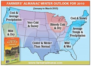 This winter will see a winter during which temperatures will average below normal for most of the nation. A large area of cold temperatures will predominate from roughly east of the Continental Divide to west of the Appalachians. But, temperature will be near or close to average near the coasts.
Near normal amounts of precipitation are expected over the eastern third of the country, as well as over the Pacific Northwest and Northern Plains, while drier-than-normal conditions are forecast to occur over the Southwest and the Upper Midwest/Great Lakes. Only the Central and Southern Plains are expected to receive above-average amounts of precipitation. While three-quarters of the country is predicted to see near- or below average precipitation this winter, that doesn’t mean there won’t be any snow weather, and significant snowfalls are forecast for parts of every zone.
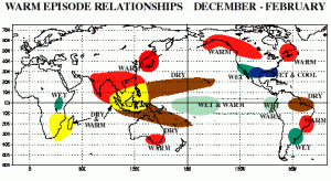 Once again, it looks as though there is a strong El Nino Pattern developing in the equatorial zone. This weather phenomenon tends to split weather systems approaching from the pacific, sending flows southward into California and north into Alaska and Canada. Though El Nino historically has been known to bring drier weather to the inter-mountain region, it also offers equal chances of wetter weather for Wyoming and Montana. So really, it can go either way for us here in the Tetons.
National Oceanic and Atmospheric Administration
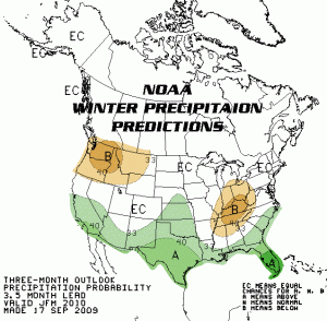 NOAA gives out long term weather predictions based on current conditions and creates maps in three month intervals relative to temperature and precipitation. Currently, NOAA’s forecast maps show a strong correlation to conditions relative to a El Nino situation in the Pacific. Drier weather conditions are predicted across the northern mountain ranges like the Pacific Northwest and Northern Montana, an equal chance of above or below average precipitation in the Inter-Mountain Region, Northern California and New England and above average precipitation in the mountains in the southern part of the country. All of this is based on just how far south the split jet-stream will push storms coming in from the west.
Either way, we know that winter is on it’s way and no matter where you live and ski, let’s all keep our fingers crossed that it leans on the wetter side of things. How ‘bout it?

“I am El Nino. Yo soy El Nino. For those of you who don’t habla espanol, El Nino is Spanish for: The Nino.”
Nice Joshua. Nice.
I live in NorCal and have about 60 fruit trees we harvest and can for winter. This year the birds, squirrels, deer and bear have decimated the majority of them early. I think if anything, it’s gonna be long and cold. The Sandhill Cranes have already flown through… according to one old timer, that’s the sign of winter.
How do you say…’All I really care about is snow on the Polish Glacier on Aconcagua.’…in Spanish?
Some interesting el nino weather links…
http://www.agu.org/pubs/crossref/2009/2008JD011637.shtml
http://www.john-daly.com/sun-enso/sun-enso.htm
and to keep the carbon bastards from their propoganda/disinformation scenario, keep an eye on…
http://arctic.atmos.uiuc.edu/cryosphere/
and as the earth keeps cooling, here’s why…
http://spaceweather.com/
http://science.nasa.gov/headlines/y2009/01apr_deepsolarminimum.htm
Thanks for those Ptor. Though most were kinda a little tough for my rando-brain to comprehend (at least early in the morning) I thought this sun-spot graph was the most interesting. Looks like some warm ones to come…eh?
RandoS.
According to meterologist Cliff Mass here at University of Washington, the famers almanac has, historically, less skill than a coin toss. You’d be better off guessing. NOAA’s track record is way better, and gets better every year. I’m not buying a seasons pass here in the PNW this year!
As for sunspots, if sunspots were a major factor, then 2008 should have been among the coolest since at least the 1970s since the sunspots were at a record low. In fact 2008 was the 9th warmest on record. The sunspot cycle has very very little effect on temperature and precipitation, and hence on skiing, relative to everything else (ocean circulation changes (e.g. El Nino), random fluctuations in the jet stream, etc.).
Cute, but not relevant!
Good info Eric. But with NOAA ‘Equal Chance” forecast…they’re not really going out on a limp or anything…eh?
So you’d rather have a definitive answer, even if its wrong? 😉
Steve: “Todo que me importa es la nieve en el glaciar de los polacos del aconcagua.”
Or something like that.
Muchas gracias Roberto!
Hey Eric,
Care to elaborate on your statement that sunspots has very little effect on temperature and precipitation given that…
i) the link I gave above was regarding a study connecting the external forcing factors of the el nino phenomenon to sunspot cycles
ii) perhaps the most accurate long range weather forecaster, Piers Corbyn, relies completely on solar phenomenon data
http://www.weatheraction.com/
iii) NASA even admits that Solar cycles are part of the equation
http://www.dailytech.com/NASA+Study+Acknowledges+Solar+Cycle+Not+Man+Responsible+for+Past+Warming/article15310.htm
Perhaps susnspot cycles are not instantly noticeable but I trhink they are far from irrelevant to the weather picture.
Also, where do you get your data from for your other “fact” regarding 2008 being the ninth warmest year on record. I remember snow in Baghdad, the coldest Chinese winter in a hundred years etc. Regardless, 2007 was definately colder…
http://wattsupwiththat.com/2008/02/19/january-2008-4-sources-say-globally-cooler-in-the-past-12-months/
which still fits in with the sunspot minimum.
Let’s just do more cloudseeding!
http://espn.go.com/action/snowboarding/blog?post=4545588
Does anyone remember the JH Daily headline from summer 2007 “FEDS APPROVE CLOUDSEEDING” then we had a 600″ winter? They approved aerial cloudseeding to increase snowpack 15% for fire hazard control. I think it worked for the past two winters. But is there any documentation about what they are doing now? (and for the record I have serious concerns about governments spraying anything over this Earth)
Oh, and I would like to comment about how ridicules it is to deny global warming, especially with short term focused arguments. You are starting to sound like Matt Drudge. The real issue is that humans are having an effect on the Earth in ways that are disrupting life cycles. As long as we don’t nuke the globe to bits, I believe that life on Earth will continue regardless of how hard we try to f— it up, just not with us humans and a slew of other presently comfortable species. The concern amongst the scientific community is of triggering a rapid climate change event (RCCE). We have polar ice cap samples that have revealed loads of historical climate data for hundreds of thousands of years. There are numerous documented RCCE’s that have spun the Earth into ice ages and such in a matter of 10-20 years. These can be caused by massive volcanoes and other natural occurrences. But we are approaching atmospheric conditions similar to those present just before other RCCEs now. To ignore that this is at least partially due to HUMAN IMPACT is ludicrous. If you want the real scoop, I found an online copy of a great book called ‘Ice Chronicles’ complied by the researchers who retrieved ice core samples near the north pole: http://books.google.com/books?id=J5GM3M8UOL4C&dq=the+ice+chronicles&printsec=frontcover&source=bl&ots=TJkUADM1zz&sig=pyt6e5jzJ0AU0cr_htOT-hExzCk&hl=en&ei=ZeTVSpWcEYGN4gbbqcHIDA&sa=X&oi=book_result&ct=result&resnum=3&ved=0CBQQ6AEwAg#v=onepage&q=&f=false
having my wedding on March 20 2010…. Having the reception HOPEFULLY outdoors… yes i know it was possibly a poor choice for Texas in MARCH, but what are the predictions for that date….? Anybody?
Hey Jason! Forecast from the Old Farmer’s Almanac says dry weather for March 2010 for Texas.
http://www.almanac.com/WEATHER/LONGRANGE
BUT…NOAA is predicting above average precipitation for most of Texas.
http://www.cpc.noaa.gov/products/predictions/long_range/lead04/off04_prcp.gif
Go figure. Good luck!
its now within a few days of thanksgiving and ur forcast for the northeast is snow storm around this time this alarms me because its 65 and warm so i dont see it happening oh and btw its a thunderstorm right now
I believe the sunspot cycle is very indicative of middle to lower elevation Sierra Nevada and Western US snowfalls (3500-5500 ft)… Seeing as Reno would hardly see decent valley snow even during the wetter winters from 1998-2002… But by the mid 2000s Reno, The same city that never saw more than 2 inches of snow at once in 2000… was getting buried almost every winter with at least a few 6-12 inch storms… One particular series of storms left up to 5 feet on the RENO VALLEY FLOOR in early 2005. Seems 2004-2009 has featured generally lower snow levels… And I do believe sun activity is in part responsible for that. The late80s-mid 90s also saw somewhat more Reno Snow too during the lower sunspot years but my memory is more vague going back that far.
Hello I live in the nothern part of Kentucky, and would like to know if theres a chance for more ice like the ice storm on Jan 27 2009. We had more then enough ice to do us in for life. Just wanting to know what kind of precip can we expect. So we can prepare. Thanks to anyone that answers. happy holidays
leila…by looking at these maps…my guess is that it is going to be cold and dry that time of year.
http://www.cpc.ncep.noaa.gov/products/predictions/30day/
i was just wondering is there any chance of significant snow or ice storms this year in columbus,Ga. Also it snowed in orlando the other day!! It is about to warm back up now but how long will it last?? please email me at raymieb89@yahoo.com
ray…noaa seems to think that it will be cold and wet in the southeast at least through march. gotta love snow in florida!!!!
http://www.cpc.ncep.noaa.gov/products/predictions/long_range/seasonal.php?lead=1
? Decrease precipitation in the northeast.
I don’t think anyone predicted February 21, 2010 as the snowiest day in over 30 years in Dallas, Tx.
Very interesting article. I live on an island on the west coast of Florida and this has been the coldest winter in my 30 years here!
[…] Almanac and the National Oceanographic Atmospheric Association (NOAA). (Oh yeah…and sunspots.) This year, the big hype and story is all about a La Nina winter. Typically the La Nina weather […]